In the previous article in this series, “Climate change does not stop at borders – neither should Europe’s response,” we looked at how Interreg provides an existing framework for countries to address environmental risks that do not fit neatly within national boundaries. Floods, droughts, wildfires and ecosystems can affect several countries simultaneously, making shared monitoring, comparable data and coordinated planning increasingly relevant.
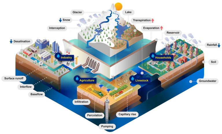
Water provides perhaps the clearest example. Rivers cross borders visibly, but the hydrological systems behind them are much more complex. Rainfall, soil moisture, groundwater, reservoirs and human water use interact across entire river basins. Managing only the section of a river that lies within one country can therefore provide an incomplete picture of the system as a whole.
The Danube illustrates the scale of this challenge. Its river basin is shared by 19 countries, making it the world’s most international river basin, according to the International Commission for the Protection of the Danube River (ICPDR). Fourteen countries with territories of more than 2,000 km² within the basin cooperate under the Danube River Protection Convention. ICPDR
One river basin, different data
A practical problem in transboundary water management is that countries have historically collected and processed water data using different national methods. The Interreg Danube Water Balance project describes water-balance information in the basin as fragmented, with differences in data availability and national calculation methods producing a mosaic of national and subregional assessments. Interreg Danube Region
The project, launched in 2024, attempts to address this by developing a harmonised water-balance modelling system for the entire Danube River Basin, covering both surface water and groundwater. It involves 20 project partners from 11 countries, while all 14 principal Danube basin countries are represented through project partners and associated strategic partners. Its budget is approximately €3.03 million, 80% financed by Interreg funds. OVF
Source: Interreg Danube Region
The project is developing an open-source basin-wide model based on jointly defined data-management protocols. It also includes an open-access data repository and tools for collecting, validating, converting and visualising information. The model is being tested in four transboundary sub-basins: the Morava, Tisza, Upper Sava and Drina. Keep.eu
This matters because a common model does more than produce another dataset. If neighbouring countries calculate water availability using compatible information and methods, they can establish a shared picture of where water is available, how that balance is changing and which areas may become more vulnerable under different climate scenarios.
Recent work in the Tisza basin illustrates the approach. At a June 2026 workshop in Szolnok, more than 40 experts from Hungary, Romania, Serbia, Slovakia and Ukraine discussed the application of the common model, its central data-storage system, Web-GIS tools and climate-related water-management challenges.
The water we see and the water we do not
River levels are only one part of water security. Surface water and groundwater are connected components of the same hydrological cycle. During prolonged dry periods, groundwater can help sustain rivers and ecosystems; at the same time, reduced recharge and continued abstraction can place additional pressure on underground reserves. ResearchGate
This is one reason why Danube Water Balance explicitly incorporates both surface water and groundwater rather than modelling rivers in isolation. Its aim is to quantify the components of the water balance across the basin and apply climate scenarios to understand how that balance could change.
The approach also connects directly with European water policy. The project states that its common methodology is intended to support river-basin management planning required by the EU Water Framework Directive. Its data-management strategy is designed to make national datasets more comparable and could provide a common basis for future water-balance assessments across the basin. ScienceDirect
The underlying principle is relatively simple: before countries decide separately how much water is available and how it should be managed, it is useful to establish a common understanding of the hydrological system they share.
From water management to landscape management
Water security is also connected to the condition of the surrounding landscape. Forests, wetlands and floodplains influence water retention, runoff and ecosystem resilience, meaning that water policy cannot always be separated neatly from biodiversity and land management.
Previous Interreg projects provide examples of this broader approach. Danube Floodplain combined transnational flood-risk management with floodplain restoration and biodiversity objectives. The Mura-Drava-Danube corridor provides another example: the five-country landscape extends across Austria, Slovenia, Croatia, Hungary and Serbia, while earlier Interreg cooperation developed transboundary approaches to managing this connected river ecosystem. ResearchGate ICDPR
Current cooperation is extending this logic to forests. The ForestConnect project involves 15 partners from seven countries and has a budget of approximately €2.95 million, 80% funded by Interreg. It uses joint monitoring, GIS databases and common management approaches to strengthen climate-resilient forest corridors across the Balkan-Carpathian-Dinaric region.
This is particularly relevant in the context of EU biodiversity policy. Primary and old-growth forests account for only around 3% of EU forest area, according to the European Commission, while the EU Biodiversity Strategy for 2030 calls for the remaining primary and old-growth forests to be strictly protected. Interreg Danube Region
One possible future application of the Interreg model could therefore be to expand long-term cross-border forest-reserve cooperation: common monitoring standards, coordinated management plans and potentially shared funding structures for ecologically connected protected forests. This would build on activities that Interreg already finances, such as harmonised management, ecological connectivity, monitoring tools and transnational biodiversity networks.
Such a model would not require forests on different sides of a border to be managed identically. Rather, financing could support the additional costs of coordination: shared biodiversity databases, compatible monitoring, joint scientific assessments, ecological-corridor management and cooperation between protected-area authorities.Interreg Central Europe
From shared risks to shared emergency networks
The same principle becomes even more tangible when environmental change turns into an emergency.
The Danube Region Programme identifies floods, droughts and forest fires among the environmental risks whose frequency or severity is expected to increase with climate change. Its current funding framework explicitly supports joint monitoring and alert systems, harmonised contingency planning, interoperability between emergency authorities and common preparedness activities. Interreg Danube Region
There is already a concrete example. The Integrated Disaster Management Network in the Danube Region (InDiMaND), launched in 2025, brings together 13 project partners from nine countries, supported by 17 associated strategic partners. With a budget of about €1.92 million, the project aims to develop a transnational disaster-management network addressing floods, wildfires, heatwaves and droughts.
Its work includes common response models, harmonised procedures, training, local exercises and field simulations. The project is also designed to complement the EU Civil Protection Mechanism by improving cooperation at regional and cross-border level.
This points to a broader possibility for future Interreg cooperation: moving from temporary exchanges of expertise towards durable cross-border disaster-management networks. Compatible warning systems, shared risk maps, common operating procedures and regular multinational exercises could allow neighbouring regions to prepare for the same hazard before an emergency reaches the border. Europa.eu
A common system before a common crisis
The Danube Water Balance project illustrates a wider principle of climate adaptation. Cooperation does not begin when a drought becomes severe or when a flood reaches another country. It begins much earlier with compatible measurements, shared datasets, common models and institutions that already know how to work together.
The same principle can apply beyond water management. Forest ecosystems can be monitored across ecological rather than political boundaries, while disaster-response organisations can develop interoperable procedures before an extreme event occurs. OVF VKKT
Interreg already finances elements of all three approaches. The Danube Region Programme supports transnational water management, joint climate and disaster-risk systems, and the protection of ecological corridors through common monitoring and management tools.
The next question is therefore one of continuity and scale. Can temporary cross-border projects evolve into lasting shared systems for managing water, forests and climate-related disasters?
For a river basin such as the Danube, this is not simply a question of administrative cooperation. It reflects the geography of the resource itself: the water is already shared. The challenge is to determine how far the institutions, data and management systems built around it can become equally interconnected.